YOUR LOCATIONS
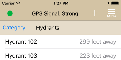
You can select the category of locations to view, and sort them by nearest location, or choose from several different view options to see exactly what you need at the moment.
Home : Emergency Response : 911 Locations
911 Locations is an app that helps you get prepared for emergencies, and assists you during the incident. With this app, you collect location-based data like building preplans, water sources, hazmat locations, landing zones, gate/lock codes, residents with special needs, etc., and it is readily accessible during an emergency. In an instant you can see locations of interest near your destination, and along your route to get there.
911 Locations was designed to be super-easy to use. Nobody wants another software tool that takes a rocket scientist to figure it out, or is too clunky to use. You can collect GPS coordinates, street address, and photos of a new location in just a few seconds! You can view your database in a list, sorted the way you like, and on a map. This is the easiest way to comply with NFPA 1620: Standard for Pre-Incident Planning.
During an incident, you can quickly enter your destination just like you would a maps app, and you will be shown any preplans that already exist near that destination. 911 Locations will even alert you when you approach a gate or lock and show you the code, for example, automatically.
AVAILABLE NOW!
You can select the category of locations to view, and sort them by nearest location, or choose from several different view options to see exactly what you need at the moment.
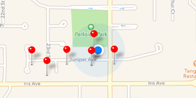
A picture is worth a thousand words, so you can view your current location and nearby locations of interest on a map
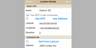
Creating a new location is a snap. Grab your coordinates from GPS, and 911 Locations will tell you the address, or vice versa. Snap some photos if you like, and enter some notes. Of course you can also import existing data from a spreadsheet.
The Tracker view tells you what is close to your current location, as well as your destination, and keeps track of arrival times.